Pedro de Valdivia founded Santiago on this rocky hill in 1541; Benjamín Vicuña Mackenna turned the neglected quarry it had become into a public park in 1874 with 150 workers and three years of obsessive landscaping.
About Cerro Santa Lucía
The Mapuche called the hill Huelén and understood it as a significant geographic marker in the flat valley. Pedro de Valdivia recognised the same qualities in military terms — a defensible position with sightlines across the valley floor — and established his colonial fort here in February 1541, making Cerro Santa Lucía the literal origin point of modern Santiago. The hill's colonial military usefulness diminished as the city grew and the front lines moved. By the nineteenth century it had been quarried and degraded, its flanks stripped of vegetation and its summit used for signal fires. Benjamín Vicuña Mackenna, appointed intendant of Santiago in 1872, identified the hill's transformation as his signature civic project. He hired workers, established a nursery for native and exotic plants, designed the terraces personally, and pushed the project to completion in 1874 despite significant political opposition to the cost. The gardens Vicuña Mackenna planted have been maintained, replanted, and supplemented across 150 years of continuous use.
Cerro Santa Lucía is a volcanic outcrop that erupts from the flat grid of Santiago's city centre like a geological argument against urban planning. The hill is 69 metres above street level, forested and terraced, its paths threading between castellated towers, fountains, and a nineteenth-century fort whose ramparts now serve as viewing platforms for a city that has grown to surround the hill on every side. The summit gives the clearest orientation view of central Santiago available without paying for an elevator.
“Cerro Santa Lucía is a volcanic outcrop that erupts from the flat grid of Santiago's city centre like a geological argument against urban planning.”
Cerro Santa Lucía, Chile
The hill was the site of Santiago's foundation in 1541, the rocky high ground that Pedro de Valdivia chose as his military base when establishing the Spanish colonial capital on the banks of the Mapocho. That founding logic — a defensible rock in a flat valley with mountain reference points in every direction — is still visible from the summit terraces.
The Mapuche name for the hill was Huelén — a word variously translated as pain or sorrow, which the Spanish colonisers replaced with the name of the saint whose feast day fell near the date of the city's foundation. The hill served its military purpose for the first century of colonial settlement, then declined into a neglected quarry site as the city developed around it.
The transformation came in 1872 under Benjamín Vicuña Mackenna, Santiago's greatest urban improver, who proposed converting the degraded quarry into a public park — a gesture explicitly modelled on European urban park design but adapted to Chilean native plant species. Vicuña Mackenna oversaw three years of construction involving 150 workers who terraced the hillside, planted the gardens, and built the castellated towers that give the hill its current fairytale silhouette. The park opened in 1874 and has been in continuous public use since.
“The park opened in 1874 and has been in continuous public use since.”
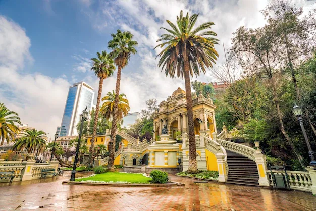
The main entrance on Alameda uses a stone gateway of theatrical proportions that opens onto a series of ascending paths. The route to the summit passes through garden terraces, past a small waterfall, and alongside the Castillo Hidalgo — a nineteenth-century fortification that now hosts events and has a terrace café with views east toward the Andes.
The summit plaza at the top of the main path is the target: a flat terrace with balustrades on all sides and a 360-degree view of the city. The Andes to the east are the dominant feature, and in winter after snowfall the contrast between the white mountains and the terracotta and grey of the city below is one of the more reliably satisfying views in South America. The hill at dusk, when the street lighting of the grid below comes on before the sky goes fully dark, is particularly good.
The main entrance is on Alameda (Avenida Libertador Bernardo O'Higgins) at the corner with Santa Lucía street. Metro line 1 at Santa Lucía station exits directly to the hill's base. The park is free to enter and opens daily from around 9am to 9pm. The summit is a 15-minute walk from the Alameda entrance on a paved path.
The Experience
The hill changes atmosphere by hour and season. In the morning it is used by Santiago's office workers cutting through on their way to the centre, moving quickly up the paths. By midday the garden terraces hold students from the nearby universities eating lunch. In the late afternoon couples arrive for the summit view, and the light on the Andes to the east shifts from white to amber as the sun drops. The Castillo Hidalgo halfway up the hill is worth stopping at — the terrace café looks east toward the mountains and serves coffee at city prices without the tourist markup. Below the castle, a grotto fountain built in 1874 runs continuously and has the green, mossy quality of something genuinely old in a city where most things are not.
Why It Matters
Cerro Santa Lucía is the founding site of Santiago and the most compressed demonstration of the city's history — colonial military position, nineteenth-century public park, present-day urban green space — all in 69 metres of vertical rock. Vicuña Mackenna's conversion of the hill established the concept of the urban public park in Chilean city planning, a precedent that influenced the design of parks across the country for the following century.
Why Visit
The hill is free, central, and gives the clearest ground-level orientation view of Santiago available without special access. The combination of the founding history, the nineteenth-century garden design, and the Andean backdrop makes it worth more than the fifteen minutes most visitors spend here.
Insider Tips
- 1
Enter from the Alameda side and exit from the Lastarria side to use the hill as a walking route between the two districts.
- 2
The summit is best in the morning before midday haze builds over the city — arrive before 10am for the clearest mountain views.
- 3
The terrace café at Castillo Hidalgo serves coffee and snacks at normal city prices; avoid the vendor carts lower on the hill which charge a significant premium.
- 4
The hill closes at 9pm but the exterior terraces along the Alameda base remain accessible — the illuminated fountains and towers visible from the street are worth seeing from the pavement.
- 5
The Santa Lucía metro station exits directly at the hill's Alameda entrance — use it rather than walking from the Plaza de Armas.