An 8.8-magnitude earthquake struck Chile while this tower was under construction — the building was unharmed and kept going up.
About Sky Costanera
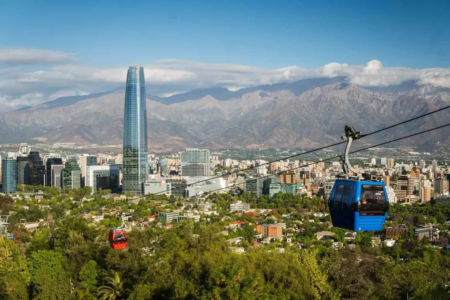
The Costanera Center project was announced in 2006 and broke ground in 2008, a private development by the Cencosud retail group that positioned the Gran Torre Santiago as both office space and a statement about Chilean economic confidence in the mid-2000s commodity boom. The 2010 earthquake, which struck at magnitude 8.8 and caused widespread damage across central Chile, interrupted construction for months while structural assessments were completed. César Pelli's design had incorporated seismic isolation at the building's base and a tuned mass damper near the top — a large pendulum that counteracts wind and seismic oscillation. The system performed as designed in 2010, and construction resumed. The tower topped out in 2011 and the full complex opened in phases through 2012 and 2013. The 300-metre height was deliberate: Pelli's brief included the specification of Latin American supremacy in height, which required surpassing the 268-metre Torre Mayor in Mexico City. The margin was calculated rather than accidental.
At 300 metres, the Gran Torre Santiago is the tallest building in Latin America, and Sky Costanera is the observation deck on its upper floors — levels 61 and 62 — where the full extent of Santiago's geography becomes suddenly, disorienting legible. The city spreads in every direction across the central valley, a grid of 7 million people interrupted by the snaking green line of the Mapocho River, enclosed to the east and northeast by the Andes in a wall of snow and rock that on clear days seems improbably close. To the west, the coastal range provides a lower horizon, and beyond it, invisible but calculable, the Pacific.
“To the west, the coastal range provides a lower horizon, and beyond it, invisible but calculable, the Pacific.”
Sky Costanera, Chile
The tower itself is part of the Costanera Center mall complex in the Providencia district, a development that was controversial during construction and is now simply part of Santiago's skyline. Sky Costanera is the reason to enter the building.
The Gran Torre Santiago was designed by Argentine architect César Pelli and completed in 2013 after a construction process that was interrupted and extended by the massive 2010 earthquake that struck Chile while the building was mid-rise. That the structure was not only unharmed but continued upward after an 8.8-magnitude seismic event was a significant engineering demonstration — the tower's design incorporated isolation and damping systems calculated for Chilean seismic conditions that are among the most demanding in the world.
The building's height — 300 metres to roof, 62 floors — made it the tallest in Latin America on completion, surpassing buildings in São Paulo and Mexico City. The observation deck opened shortly after the tower's completion and has operated since as the highest publicly accessible vantage point in the region.
“The building's height — 300 metres to roof, 62 floors — made it the tallest in Latin America on completion, surpassing buildings in São Paulo and Mexico City.”
The ascent takes 35 seconds in a high-speed elevator, which is long enough to register the altitude change through mild pressure in the ears. The viewing floor is enclosed in glass on all four sides with interior displays explaining the geography and identifying the peaks visible to the east. The Andes panorama is the primary event: Aconcagua, the highest peak in the Americas at 6,961 metres, is visible on clear days to the northeast, and the closer peaks of the Santiago metropolitan region — El Plomo, Tupungato — fill the foreground with permanent snow.
Santiago's notorious smog reduces visibility on most summer days between December and March, when thermal inversions trap pollution in the valley. The viewing experience is fundamentally different on a clear winter day, when the air is cold and the mountains carry fresh snow and the city grid extends without interruption to the edges of the valley.
Costanera Center is in the Providencia district, served by metro line 1 at Tobalaba station, three minutes' walk from the mall entrance. Sky Costanera operates daily with last entry approximately one hour before closing. Tickets are available online with a small discount over the door price.
The Experience
The compressed timeline of the elevator ride is a useful preparation for the scale change at the top. You step out into a room where Santiago extends in every direction below the window ledge, and the first instinct is to find a reference point — the Plaza de Armas, the river, the Mapocho — before accepting the city as a whole. The Andes on a clear day are the detail most visitors do not anticipate. The mountains are not in the distance; they are present and specific, individual peaks named on the interior display panels, their snow lines at an altitude that the tower approaches from below. In July and August, after heavy snowfall, the wall of white to the east occupies perhaps a third of the eastern window view.
Why It Matters
Sky Costanera is the highest publicly accessible observation point in Latin America and the most complete vantage from which to understand Santiago's peculiar geography — a major city compressed between two mountain ranges in a valley that determines its air quality, its water supply, its expansion limits, and its seismic risk simultaneously. The view makes all of that geography readable at once.
Why Visit
Santiago's ground-level geography is difficult to grasp in the city's dense central grid. From Sky Costanera, the valley structure is immediately clear — the Andes to the east, the coastal range to the west, the river cutting west through the centre, the urban sprawl running up against the mountains to the north and south. No map produces the same understanding.
Insider Tips
- 1
Check the air quality index (IQA) for Santiago before going — on red alert days the view extends less than 10 kilometres and the mountains are invisible.
- 2
Buy tickets online the day before; the door queue in summer can add 30 minutes to the visit.
- 3
The best Andes view is from the eastern windows in the morning before midday heat haze builds over the valley.
- 4
The mall below Sky Costanera is among the largest in Latin America — allow time if arriving by foot from Tobalaba metro, as the building entrances are not immediately obvious from street level.
- 5
Winter weekday mornings between 10am and noon are the least crowded window for the observation deck.