A sliver of stone hangs 700 meters over a glacial lake, inviting the brave to stand on a literal 'troll's tongue' that survived ten thousand years of ice and wind.
About Trolltunga
While the rock has existed since the end of the last ice age, the modern trail was largely defined by the industrial development of the early 20th century. The nearby Tyssedal power station was one of the largest in the world when it opened, and the paths used by maintenance workers eventually became the base for the hiking route. Until about 2010, Trolltunga saw fewer than 1,000 visitors per year; today, that number exceeds 80,000. This rapid growth led to the creation of the Trolltunga Trail Knights, a volunteer group that maintains the path and assists exhausted hikers, ensuring the fragile mountain ecosystem isn't trampled into oblivion.
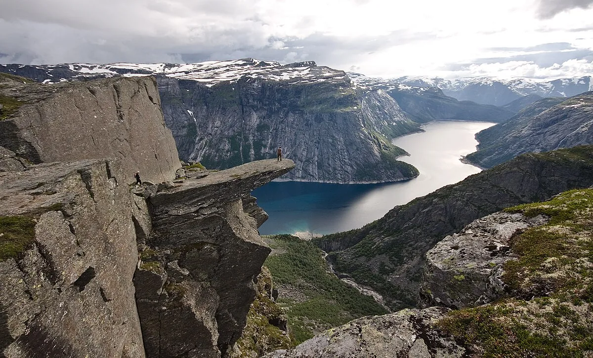
Suspended 700 meters above the Ringedalsvatnet lake, Trolltunga is a thin horizontal slab of rock that looks like a literal tongue protruding from the mountain. It is perhaps the most iconic image of the Norwegian wilderness—a geological freak of nature that attracts thousands of hikers who are willing to endure a grueling day of physical exertion for a few seconds of solitude on the edge. The plateau sits at 1,100 meters above sea level, surrounded by a moon-like landscape of granite and glacier-scoured valleys. This is not a casual walk; it is a pilgrimage through the heart of the Hardangervidda, where the weather can turn from sun to sleet in minutes.
“Suspended 700 meters above the Ringedalsvatnet lake, Trolltunga is a thin horizontal slab of rock that looks like a literal tongue protruding from the mountain.”
Trolltunga, Norway
Trolltunga was carved by the retreat of the glaciers approximately 10,000 years ago. As the ice pulled back, the sudden release of pressure and the freezing of meltwater in rock crevices caused large sections of the mountain to fracture, leaving this cantilevered sliver of stone behind. For centuries, it was known only to local reindeer hunters and shepherds who traversed the high plateaus. It entered the global consciousness only recently, fueled by the rise of social media and a growing appetite for extreme landscape photography. The trail itself has a history of its own; part of the route used to follow the Mågelibanen funicular, built in 1911 to transport workers and materials for the local hydroelectric power plants that still hum in the valley below.
The hike begins with a punishing ascent that sets the tone for the day. You feel the transition from the lush green of the valley to the dwarf birch and then the bare, lichen-covered stone of the high mountains. The air is thin and carries the sharp, cold scent of wet granite. You notice the sound of your own breathing and the rhythmic clack of trekking poles against the rock. After hours of walking through a seemingly endless series of ridges, the 'tongue' finally appears. You feel a jolt of adrenaline as you approach the edge; the drop is vertical and absolute. Standing on the rock, you notice the deep, vibrant blue of the lake far below, which looks like a sheet of glass. The wind up here is erratic, tugging at your clothes and carrying the distant sound of hidden waterfalls.
The trek starts in Skjeggedal, near the town of Odda in the Hardanger region. Reaching Odda involves a scenic drive of about three hours from Bergen or six hours from Oslo. From the main parking lot at P2, most hikers take a shuttle bus to P3 (Mågelitopp) to save themselves the first four kilometers of steep uphill road. Even with the shuttle, the round-trip hike is 20 kilometers and takes between 7 and 10 hours, requiring proper gear and significant physical fitness.
“The trek starts in Skjeggedal, near the town of Odda in the Hardanger region.”
The Experience
The fatigue in your legs is forgotten the moment you step onto the plateau and see the scale of the fjord. You notice the queue of hikers waiting for their turn on the rock, a strange social ritual in such a remote place. You feel the temperature drop as the sun hides behind a peak, turning the warm stone to a cold, biting grey. You notice the tiny, resilient wildflowers that grow in the cracks of the rock, a contrast to the massive, indifferent landscape. The moment that stays with you isn't the photo on the tongue, but the walk back in the golden evening light, when the mountains seem to glow from within and the lake below turns to ink.
Why It Matters
Trolltunga is more than a photo opportunity; it is a symbol of Norway’s 'Allemannsretten' (the right to roam). It represents the challenge and the reward of the Nordic outdoors, where nature isn't sanitized for safety but left raw and demanding. It serves as a vital economic engine for the Hardanger region and a focal point for discussions about sustainable tourism in fragile environments.
Why Visit
Visit Trolltunga because the view is earned, not given. Unlike Preikestolen, which is a relatively short walk, Trolltunga requires a full day of commitment. Standing on that ledge gives you a visceral understanding of the earth's architecture and a sense of accomplishment that a roadside lookout can never provide.
Insider Tips
- 1
Book the shuttle from P2 to P3 in advance; it saves you the most boring and painful part of the hike, allowing you to enjoy the high plateau longer.
- 2
Start your hike at dawn; not only will you beat the heat, but you'll avoid the three-hour queue that often forms at the rock itself by midday.
- 3
Pack more water than you think you need; while there are mountain streams, they can be sparse during a dry summer, and the ascent is dehydrating.
- 4
Don't ignore the 'Mountain Code' signs; the weather here changes with terrifying speed, and people are rescued every week for being under-equipped.
- 5
The best photo angle isn't actually on the tongue, but from the cliff slightly above and to the side, which captures the full cantilevered effect.