Ten million caimans outnumber the human residents of this watery wilderness, where the largest cat in the Americas hunts along riverbanks that disappear entirely beneath the summer floods.
About Pantanal Matogrossense
The Pantanal formed during the Upper Paraguay Basin's slow sinking, creating a bowl that collects the runoff from the surrounding highlands. For centuries, the Guató Indians lived as 'water nomads' here, using bark canoes to traverse a landscape that shifted weekly with the rains. The 1700s brought the 'Bandeirantes' from São Paulo in search of gold and slaves, but they found instead a land better suited for cattle. These early ranchers adapted to the cycle of the water, creating a unique 'Pantaneiro' culture of rugged cowboys who move thousands of head of cattle across flooded plains. The establishment of the National Park in 1981 and its later recognition as a UNESCO World Heritage site in 2000 transformed the area's reputation, turning it from a remote cattle frontier into the world's premier destination for spotting the elusive jaguar in the wild.
Water dictates the rhythm of life in this vast alluvial basin, where the boundaries between earth and sky blur during the great summer floods. Spanning a territory larger than many European nations, the Pantanal Matogrossense stands as the world's largest tropical wetland, a mosaic of flooded grasslands, gallery forests, and crystalline rivers. Unlike the dense, vertical secrecy of the Amazon, the landscape here is horizontal and exposed. Jagged yacare caimans line the riverbanks like prehistoric statues while the jabiru stork, the region’s feathered sentinel, nests atop lonely cambará trees. The air smells of wet silt and crushed hyacinth, vibrating with a primordial energy that feels unchanged since the Pleistocene.
Geological subsidence millions of years ago created this massive depression, which now acts as a giant reservoir for the Paraguay River and its tributaries. Indigenous groups like the Guató people navigated these labyrinthine waterways for millennia, developing a culture inextricably linked to the pulse of the flood. European presence began in the 18th century as gold seekers and cattle ranchers arrived, leading to the establishment of the massive 'fazendas' that still define the region’s social fabric today. President Getúlio Vargas first recognized the need for environmental protection here in the 1930s, but it was not until 1981 that the National Park was officially established to curb the threats of poaching and unregulated agriculture. This transition marked a shift from a frontier of extraction to a global sanctuary for biodiversity.
Dust kicks up in fine, red plumes behind your horse as you navigate the transition zones between dry 'cordilheiras' and the encroaching marsh. You notice how the soundscape changes as the sun dips; the raucous chatter of hyacinth macaws gives way to the low, guttural growl of a howler monkey hidden in the canopy. The heat is a constant, heavy presence, but it breaks during the afternoon thunderstorms that turn the horizon into a theater of violet clouds and jagged lightning. In the quiet reaches of the Cuiabá River, you might see the water ripple as a giant river otter surfaces, its whiskers dripping with the tannin-stained water of the swamp.
Nightfall brings a different kind of intensity. The sky, far from city lights, becomes a crowded map of the Milky Way, while the eyes of thousands of caimans reflect your flashlight like floating embers in the dark. You feel the immense solitude of the wetlands, a place where humans are clearly the minority. The most profound moment usually occurs at dawn, when the mist rises off the water and the entire Pantanal awakens in a cacophony of birdcalls that sounds like a frantic, beautiful orchestra tuning up for the day.
Access begins at the gateway city of Cuiabá, where the pavement of the Transpantaneira highway starts its 147-kilometer stretch into the heart of the marsh. This dirt road, punctuated by over a hundred creaking wooden bridges, serves as a continuous safari trail where wildlife sightings begin before you even reach your lodge. Small bush planes offer a more direct route to remote eco-lodges, providing an aerial perspective of the silver veins of water that keep this ecosystem breathing. Traveling here requires a slow pace and a sturdy 4x4 vehicle, as the mud during the transition months can swallow a lesser tire in seconds.
The Experience
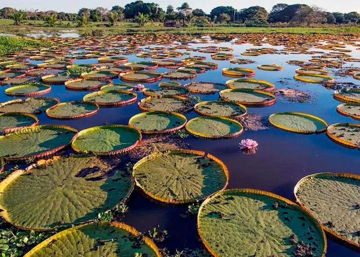
A thick, humid heat clings to your skin like a second layer, smelling faintly of sun-baked grass and river water. You notice the way the light turns a deep, saturated orange just before the sun vanishes, silhouetting the massive nests of the jabiru storks against a bruised sky. Most visitors focus on the jaguars, but the real magic is found in the smaller details: the iridescent flash of a kingfisher or the way a giant lily pad creates a perfect, floating island for a jacana bird. You feel the silence of the marsh at noon, a heavy stillness that is suddenly broken by the splash of a capybara family retreating into the safety of the reeds. The sheer density of life is overwhelming; you are never more than a few feet away from something breathing, hunting, or nesting. It is a place that demands you put down the binoculars and simply listen to the hum of the dragonflies and the distant, rhythmic splashing of a horse crossing a shallow channel.
Why It Matters
This wetland functions as a vital kidney for the South American continent, filtering vast amounts of water and supporting a density of wildlife that puts the Amazon to shame. It is the last great stronghold for the hyacinth macaw and the giant river otter. Culturally, it preserves the tradition of the Pantaneiro rancher, a human presence that has learned to coexist with the seasonal floods rather than trying to drain them.
Why Visit
Go to the Pantanal because the Amazon is too good at hiding its secrets. Here, the animals have nowhere to hide, and the vast, open skies provide a stage for nature’s most spectacular daily dramas. You visit because it is the only place on earth where you can reliably see a jaguar hunt in broad daylight from the safety of a small boat.
✦ Photo Gallery
Best Season
🌤 Plan your visit between July and September, when the water retreats into small pools, forcing the animals to congregate and making the jaguars much easier to spot on the exposed riverbanks.
Quick Facts
Location
Brazil
Type
attraction
Coordinates
-17.6720°, -57.4450°
Learn More
Wikipedia article available
Insider Tips
- 1
Pack a high-quality pair of binoculars with at least 8x magnification, as the most incredible bird life often thrives in the high canopy of distant gallery forests.
- 2
Wear neutral-colored, long-sleeved clothing to protect against both the intense equatorial sun and the persistent 'mutuca' biting flies.
- 3
Check the integrity of every wooden bridge on the Transpantaneira before crossing in a heavy vehicle, as the termites and humidity often rot the supports from within.
- 4
Book a night safari at least once; the landscape transforms completely after dark when the tapirs and ocelots emerge from the shadows.
- 5
Hire a local guide who grew up in the region, as their ability to spot a camouflaged jaguar in a thicket of reeds borders on the supernatural.