Snow walls six meters high often flank this road well into June, creating a white-walled canyon that leads to a view of three hundred mountain peaks.
About Großglockner Hochalpenstraße
Franz Wallack’s proposal for a high-altitude road was initially mocked as a 'luxury for the wealthy' during a time of national poverty. However, the project became a symbol of Austrian resilience, employing over 3,000 workers during the height of the Great Depression. The labor was grueling; men lived in high-altitude camps for months, clearing millions of cubic meters of rock to pave a path that reaches 2,504 meters at the Hochtor pass. This pass actually follows an ancient Celtic and Roman trade route where archaeologists have discovered bronze statues and coins, proving that humans have been braving these heights for millennia. Since its completion in 1935, the road has evolved into a national monument, preserved with the same meticulous care as the Viennese palaces, serving as a gateway to the largest nature reserve in the Alps.
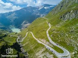
High above the treeline, where the air grows thin and tastes of ancient ice, thirty-six hairpin bends coil like a serpent around the shoulders of Austria’s highest peak. The Großglockner High Alpine Road functions as a spectacular, asphalt balcony overlooking the Hohe Tauern National Park, bridging the provinces of Salzburg and Carinthia. The landscape here transitions rapidly from lush, cow-bell-ringing meadows into a stark, lunar world of shattered slate and permanent snow. Unlike a highway designed for speed, this path was engineered for the gaze, forcing drivers to slow down as the jagged pyramid of the Großglockner looms larger with every switchback. It remains a place where the sheer verticality of the Alps becomes a tangible, heart-thumping reality, felt in the cooling of the brakes and the sudden, crystalline clarity of the mountain light.
Civil engineer Franz Wallack stood before a skeptical Austrian government in 1924, pitching a road that many deemed a financial folly in a country crippled by post-war inflation. Construction finally began in 1930, providing much-needed work for thousands of unemployed men who battled alpine blizzards and permafrost using little more than picks, shovels, and courage. Wallack’s genius lay in his refusal to use tunnels; he wanted the traveler to remain in constant dialogue with the sky. When the road opened in 1935, it revolutionized alpine tourism, transforming a journey that once took days on foot into a cinematic drive. Today, the route still follows Wallack's original vision, though the receding Pasterze Glacier at the Kaiser-Franz-Josefs-Höhe serves as a sobering, modern chapter in the mountain's long geological biography.
Ascending toward the Edelweißspitze, the highest point accessible by car, you feel the steering wheel vibrate over the traditional granite cobblestones that still line the upper curves. The soundscape is a surprising mix of whistling marmots and the distant, thunderous crack of shifting glacial ice echoing from the Pasterze. You notice the light at dawn has a peculiar violet hue, catching the frost on the purple saxifrage that clings to the rocks. Standing at the Fuscher Törl, you feel the wind coming off the north face with a ferocity that can drop the temperature by ten degrees in a matter of seconds. Most visitors overlook the small, stone-built 'Wallackhaus' where the original workers slept, a humble monument to human persistence. The moment that stays with you is the final approach to the glacier, where the sheer scale of the ice makes the cars in the parking lot look like colorful grains of sand against a wall of white and blue.
The adventure typically begins at the toll gate in Bruck, south of Zell am See, or from Heiligenblut in the south. The road is a dead-end for much of the winter, usually cleared of its massive snowpack by specialized rotary plows only in early May. Drivers should ensure their cooling systems and brakes are in peak condition, as the descent involves long stretches of intense friction. For those without a vehicle, the 'Glocknerbus' offers a curated journey from various regional hubs, allowing you to keep your eyes on the precipices while someone else handles the white-knuckle turns. Every kilometer is marked with historical plaques, turning the drive into a slow, uphill reading of Austrian engineering history.
The Experience
You notice the scent of the air changes as you climb, moving from the resinous smell of larch forests to the dry, sterile metallic tang of high-altitude rock. The light at the Fuscher Lacke pond creates a perfect, emerald reflection of the surrounding ridges, a stillness that feels fragile in the face of the shifting mountain weather. You feel a sense of vertigo not from the heights, but from the speed at which the seasons change; you can leave a summer afternoon in the valley and find a winter gale at the summit in less than forty minutes. The thing most visitors overlook is the 'Glockner Window' near the Hochtor, a natural rock opening that frames the peak with uncanny precision. The moment that stays with you is the silence that falls when you turn off the engine at a lookout, leaving only the sound of the wind and the occasional clatter of a falling stone.
Why It Matters
The Großglockner High Alpine Road is more than a transit route; it is a masterpiece of technical heritage that harmonizes with the extreme topography of the Hohe Tauern. It matters as a testament to the 1930s 'heroic' age of engineering and as a critical vantage point for witnessing the impact of climate change on the Eastern Alps. Humanly, it represents the democratic opening of the high mountains to anyone with a set of wheels and a sense of curiosity.
Why Visit
Other passes are built to get you from point A to B, but this road is the destination itself. You visit because it offers the only place in Europe where you can park your car and walk directly onto the edge of a massive glacier without a mountaineering harness. It is a thirty-six-turn symphony of rock, ice, and engineering that makes every other mountain drive feel like a driveway.
✦ Photo Gallery
Best Season
🌤 September is the connoisseur’s choice; the summer tourist traffic has vanished, the air is at its clearest for long-distance photography, and the first dusting of autumn snow begins to highlight the jagged ridges.
Quick Facts
Location
Austria
Type
attraction
Insider Tips
- 1
Test your brakes at the designated 'Brake Check' stations during the descent to ensure they haven't overheated and lost their stopping power.
- 2
Look for the marmots near the Kaiser-Franz-Josefs-Höhe; they have become surprisingly bold and will often pose for photos if you stay quiet and move slowly.
- 3
Pack a heavy winter jacket even if it is thirty degrees in the valley, as the temperature at the Hochtor pass can hover near freezing even in July.
- 4
Arrive at the toll gate by 6:00 AM to experience the 'Light of the Gods' as the sun hits the Großglockner peak before the tour buses arrive.
- 5
Drive the cobbled branch road to the Edelweißspitze for a 360-degree panorama that includes thirty peaks over three thousand meters.