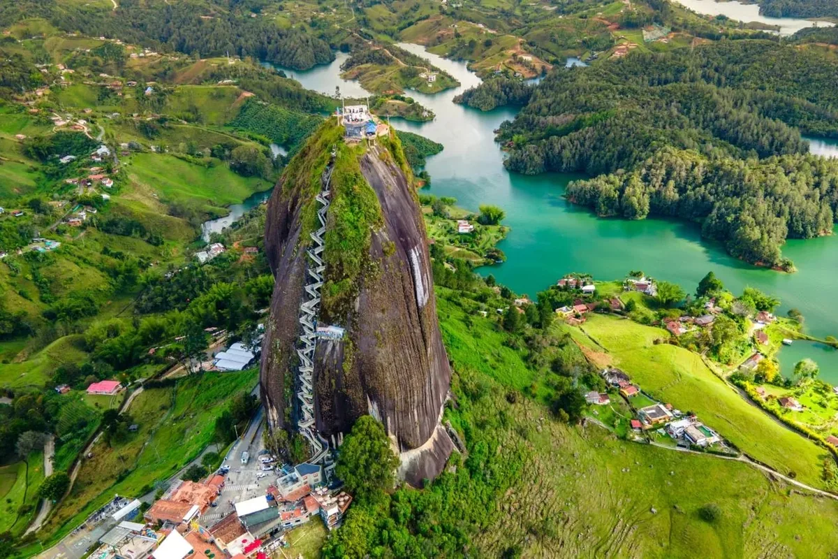
A 200-meter granite monolith rises from a flooded Antioquia valley, and a staircase built into its natural crack leads to a summit view over hundreds of reservoir islands. The old town that the dam drowned is still partially visible below the waterline.
About El Peñón de Guatapé
The granite monolith formed 70 million years ago and was sacred to pre-Columbian Zenu people. The surrounding reservoir was created in the 1970s when the Nare River valley was dammed for hydroelectric power, submerging the original town of El Peñol. The staircase in the rock's crack was built in 1954.
Overview El Peñón de Guatapé is a 200-meter granite monolith rising from the reservoir landscape of Antioquia Department, 79 kilometers east of Medellín. A staircase of 740 steps, built into a natural crack on the rock's face, ascends to a platform at the summit with 360-degree views over the Embalse Guatapé — a reservoir of islands, peninsulas, and flooded villages created by the Hidroeléctrica Jaguas dam in the 1970s. The surrounding water and the hundreds of islands visible from the summit produce a view with no equivalent in the Colombian Andes.
The Story Behind It The granite monolith formed 70 million years ago through volcanic activity and stands 2,135 meters above sea level, having resisted the erosion that wore down the surrounding terrain. Pre-Columbian Zenu people held the rock as sacred, calling it La Piedra del Peñol — the Stone of the Hill. The modern reservoir that surrounds it was created in the 1970s when the Nare River valley was flooded for hydroelectric power, submerging the original town of El Peñol (residents were relocated to a planned town 2 kilometers away). Remnants of the old church steeple remain visible above the waterline during dry season. The staircase cut into the rock's crack was built in 1954 and extended several times as tourism developed.
What You'll Experience The climb takes 20 to 40 minutes depending on fitness and the staircase traffic — the crack is narrow enough that ascending and descending visitors must negotiate passage. At the summit, the reservoir landscape extends in all directions with hundreds of visible islands, boat wakes, and the distant ridgelines of Antioquia. The town of Guatapé below the rock is known for its zócalos — brightly colored bas-relief panels on building exteriors depicting scenes of local life — and warrants a walk after the descent.
Getting There Guatapé is 2 hours by bus from Medellín's Terminal del Norte. The rock is 1 kilometer from the town; tuk-tuks connect them. Day tours from Medellín are widely available.
The Experience
A 740-step climb through a narrow rock crack to a summit platform with 360-degree views over the Embalse Guatapé reservoir — hundreds of islands, flooded valleys, and the distant Antioquia ridgeline — followed by a walk through Guatapé's bas-relief decorated streets.
Why It Matters
El Peñón is the most visited natural landmark in Antioquia and combines geological antiquity, a submerged town narrative, and a reservoir landscape created within living memory — a compressed Colombian story of nature, hydro-engineering, and displacement.
Why Visit
The summit view over a landscape of hundreds of islands in a man-made reservoir — visible only because a town was flooded — is a combination of natural and human geography that exists nowhere else in Colombia.
✦ Photo Gallery
6 photos of El Peñón de Guatapé · click to enlarge
Best Season
🌤 Year-round; Antioquia's climate is mild. Weekdays are significantly less crowded on the staircase than weekends.
Quick Facts
Location
Colombia
Type
attraction
Coordinates
6.2195°, -75.1792°
Learn More
Wikipedia article available
Insider Tips
- 1
Visit on a weekday — the narrow staircase becomes very slow on weekends when both directions compete for the crack.
- 2
Allow time in Guatapé town after the rock — the zócalo bas-reliefs on building exteriors are excellent.
- 3
The submerged church steeple is visible from the water during dry season; boat tours point it out.