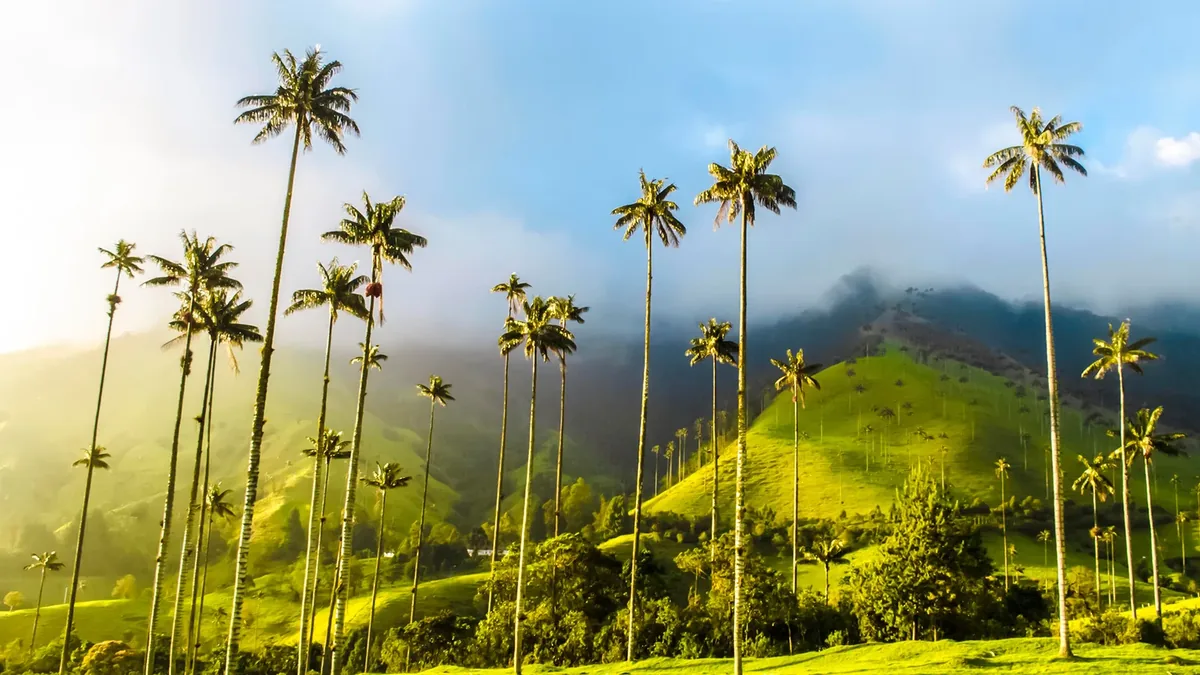
Colombia's national tree grows to 60 meters in this Andean valley — the tallest palm species on earth, rising through morning cloud from open cattle pasture in the Andes. The effect is exactly as improbable as it sounds.
About Valle de Cocora
The wax palm was designated Colombia's national tree in 1985 partly to protect it from the cut-frond trade for Palm Sunday. The Valle de Cocora holds the largest accessible concentration of adult specimens. The valley remains working farmland, with cattle grazing among the palms.
Overview The Valle de Cocora in Quindío Department is a high Andean valley where Colombia's national tree — the wax palm — grows to heights of up to 60 meters, making them the tallest palm species on earth. The combination of open highland pasture, low cloud, and palm trunks rising 50 or 60 meters with their crowns disappearing into mist produces a landscape that looks like a botanical illustration of something implausible. The valley is within the Los Nevados National Natural Park buffer zone.
The Story Behind It The wax palm — Ceroxylon quindiuense — is endemic to the Colombian Andes and was designated Colombia's national tree in 1985. At the time, significant pressure from the cut-palm-frond trade for Palm Sunday was threatening populations, and the national designation brought protective attention. The Valle de Cocora holds the largest accessible concentration of adult wax palms in the country, and the open pasture setting allows the full height to be appreciated in a way that forest-growing specimens don't permit. The valley was historically farmland and still has working cattle; the palms co-exist with the pastoral landscape rather than being separated from it in a reserve.
What You'll Experience The standard circuit hike from the Cocora valley floor — approximately 4 hours — climbs through cloud forest to a hummingbird sanctuary before descending back through the open palm valley. The hummingbird feeders at the forest station draw multiple species at close range. The return walk through the open valley, with the palms at their full visible height, is the landscape sequence the place is known for. Cloud cover is frequent and changes the valley's character quickly — open sunny pasture and mist-obscured towers can alternate within the same hour.
Getting There The Valle de Cocora is 12 kilometers from Salento, the main town of the coffee region. Jeeps run from Salento's central plaza (frequent departures from 6am). Salento is a 3-hour bus journey from Bogotá, or accessible from Pereira (1 hour) and Armenia (45 minutes).
The Experience
A 4-hour circuit hike through cloud forest — with hummingbird feeders drawing multiple species at close range — returning through the open valley with the palms at their full 60-meter height, frequently moving in and out of cloud.
Why It Matters
The Valle de Cocora is the most accessible location to observe Ceroxylon quindiuense, an endemic species found only in the Colombian Andes, at the scale that makes its height meaningful. The conservation story around the national tree designation is part of the site's context.
Why Visit
A landscape of 60-meter palms rising through cloud in open cattle pasture is a visual combination that exists nowhere else on earth. The hike structure gives it physical engagement rather than just a viewpoint.
✦ Photo Gallery
Best Season
🌤 December through February and June through August for drier conditions. The cloud forest section of the hike is beautiful in any weather; the open valley is most dramatic when cloud alternates with clarity.
Quick Facts
Location
Colombia
Type
attraction
Coordinates
4.6333°, -75.4833°
Learn More
Wikipedia article available
Insider Tips
- 1
Take the jeep to the far end of the valley and walk back toward Salento — this gives you the best light on the palms in the afternoon.
- 2
Wear waterproof boots — the cloud forest section crosses multiple small streams and is frequently muddy.
- 3
The hummingbird sanctuary mid-hike warrants twenty minutes of stillness at the feeders.