A thin dark stripe in a Danish chalk cliff marks the exact moment sixty-six million years ago when an asteroid ended the Cretaceous — and you can put your finger on it.
About Stevns Klint
Stevns Klint's Cretaceous-Paleogene boundary layer became critical evidence for the Alvarez asteroid impact hypothesis in the 1980s. The site was inscribed as a UNESCO World Heritage Site in 2014 for its geological significance and accessibility.
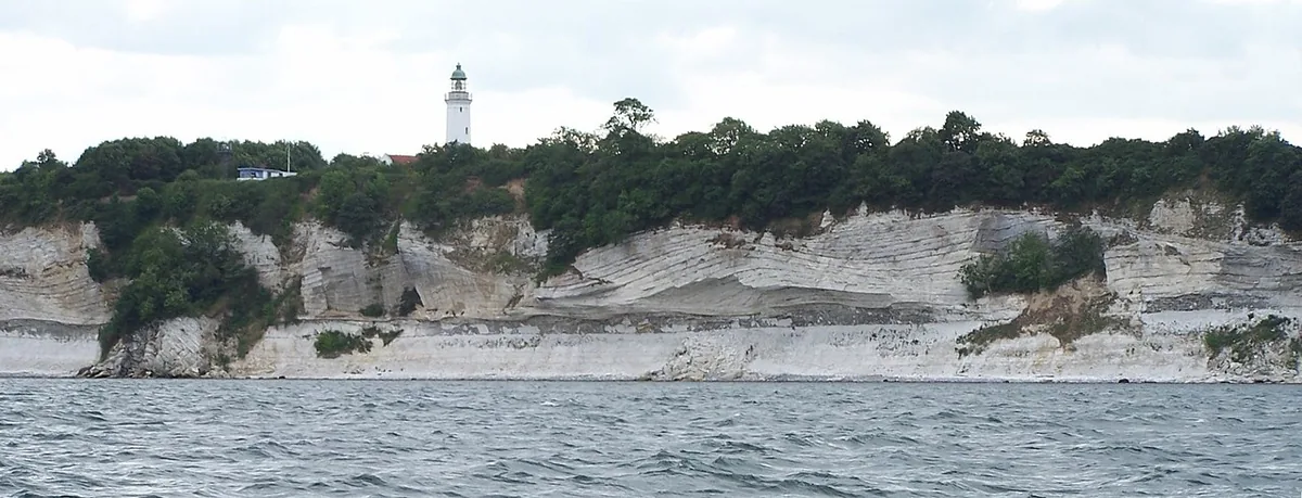
Overview Stevns Klint is a chalk cliff formation on the eastern coast of Zealand, about forty-five kilometers south of Copenhagen. The cliffs stretch for fifteen kilometers along the coast and reach heights of around forty meters. They are a UNESCO World Heritage Site, inscribed in 2014, for a specific geological reason: the cliff face contains the most accessible and complete exposure of the Cretaceous-Paleogene boundary in the world — the thin dark layer of clay that marks the precise moment sixty-six million years ago when the asteroid impact ended the Cretaceous period.
“Overview Stevns Klint is a chalk cliff formation on the eastern coast of Zealand, about forty-five kilometers south of Copenhagen.”
Stevns Klint, Denmark
The Story Behind It The Cretaceous-Paleogene boundary — commonly called the K-Pg boundary — is visible as a distinct dark stripe in the pale chalk at Stevns Klint, roughly five centimeters thick and enriched with iridium from the asteroid impact. The site became scientifically significant after the 1980 publication of the Alvarez hypothesis, which proposed that the extinction event was caused by an asteroid. The boundary at Stevns Klint provided some of the most important physical evidence confirming the hypothesis. The Cold War-era Stevnsfort bunker system, carved into the cliff base, adds a twentieth-century layer to the geological history.
What You'll Experience The cliff walk from Højerup to Rødvig passes the most dramatic sections of the formation. The old church at Højerup — Højerup Gamle Kirke — stands at the cliff edge with part of its churchyard already fallen into the sea due to ongoing erosion, and the remaining church is propped and stabilized but remains visibly precarious. The Stevns Klint Museum interprets both the geological and Cold War history. The Stevnsfort bunker complex can be visited on guided tours and is carved directly into the chalk.
Getting There Stevns Klint is about an hour from Copenhagen by car, heading south on the E20 then following Route 209 toward Store Heddinge. Public buses run from Køge. The cliff walk is accessible from multiple points along the coast.
“Getting There Stevns Klint is about an hour from Copenhagen by car, heading south on the E20 then following Route 209 toward Store Heddinge.”
The Experience
Walk the fifteen-kilometer cliff path from Højerup to Rødvig, see the K-Pg boundary layer in the cliff face, visit the cliff-edge church with its eroded churchyard, and tour the Cold War Stevnsfort bunker carved into the chalk below.
Why It Matters
A UNESCO World Heritage Site containing the world's most accessible exposure of the Cretaceous-Paleogene boundary — the geological record of the asteroid impact that ended the age of dinosaurs.
Why Visit
The experience of standing at the point where geological time becomes viscerally legible — a five-centimeter stripe separating two eras — is unlike any conventional heritage site visit. The cliff-edge church adds a human counterpoint to the deep time.
Insider Tips
- 1
The K-Pg boundary layer is visible at multiple points along the cliff — look for the thin dark stripe at about mid-cliff height in the pale chalk.
- 2
The Stevnsfort bunker tour takes about ninety minutes and is temperature-controlled inside the cliff — bring a layer even in summer.
- 3
The Højerup church is structurally stabilized but remains close to the cliff edge — the view of the remaining churchyard is striking.
- 4
Park at Højerup and walk toward Rødvig for the best cliff sections, returning by bus or taxi.