“Three times more stone was moved to build this cloud-forest fortress than the Great Pyramid of Giza, yet it remained hidden from the world for three hundred years.”
About Kuélap
The Chachapoya culture flourished in this high-altitude frontier, creating a unique architectural style characterized by circular dwellings and intricate stone mosaics. Kuélap served as the political and religious center of a loose confederation of chiefdoms. In the late 15th century, the Inca Empire finally subdued the 'Cloud Warriors' after a series of brutal campaigns, though the Chachapoya frequently rebelled. Following the Spanish arrival, the survivors were relocated into colonial towns, leaving Kuélap to the mercies of the encroaching jungle. Modern research has revealed evidence of a final, violent confrontation within the walls, suggesting the city's end was as dramatic as its construction.
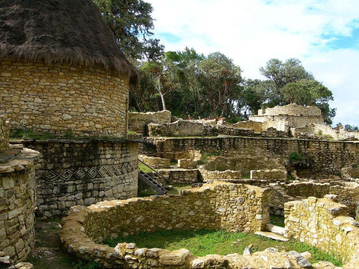
High above the Utcubamba Valley in the northern cloud forests, the walled city of Kuélap sits like a crown on a limestone ridge. This massive fortress-city was the stronghold of the Chachapoya people, the 'Warriors of the Clouds,' who lived at the edge of the Amazonian basin. The site is defined by its colossal outer walls, some reaching twenty meters in height, built from precisely cut limestone blocks. Inside the enclosure, hundreds of circular stone houses are scattered across several levels, many still decorated with the zigzag and rhomboid friezes typical of Chachapoyan art. The atmosphere is frequently mist-shrouded, with bromeliads and moss-covered trees growing directly out of the ruins. Kuélap offers a rugged, vertical alternative to the more famous sites of the south, feeling like a discovery rather than a destination.
High above the Utcubamba Valley in the northern cloud forests, the walled city of Kuélap sits like a crown on a limestone ridge.
Construction began around the 6th century AD, centuries before the rise of the Inca, and continued for nearly a thousand years. The Chachapoya were a fiercely independent people who resisted both Inca and Spanish expansion for as long as possible. The sheer volume of stone moved to build the walls—estimated to be three times that of the Great Pyramid of Giza—points to a highly organized and motivated society. The city was eventually abandoned in the late 16th century following the Spanish conquest and the arrival of European diseases. It remained hidden by the dense cloud forest until 1843, when a local judge chanced upon the walls while looking for land to cultivate. Since then, it has slowly emerged as the most important archaeological site in northern Peru, though it still sees a fraction of the crowds found at Machu Picchu.
Gliding toward the ridge in the modern cable car, you notice the landscape transform from dry valley floor to emerald-green mountain peaks. The sound of the wind through the high-altitude trees is punctuated by the calls of tropical birds that inhabit the surrounding canopy. You notice the narrow, funnel-like entrances to the city, designed so that only one person could enter at a time, a brilliant defensive feature. You feel the humidity of the cloud forest clinging to the stone, making the ruins feel like a living part of the mountain. Most visitors overlook the 'Tintero' or inkwell building, a unique inverted cone structure whose purpose remains a mystery to archaeologists. You notice the delicate orchids growing in the crevices of the limestone, a splash of color against the ancient grey walls. The moment that stays with you is standing at the edge of the southern rampart, looking down at a 3,000-meter drop into the valley below.
The primary gateway to Kuélap is the town of Chachapoyas, reachable via a long bus ride from Chiclayo or occasional flights from Lima. From Chachapoyas, a one-hour drive leads to the village of Tingo, where the cable car system begins. The cable car provides a spectacular twenty-minute ride that bypasses what used to be a grueling uphill hike. Once at the top, a paved path leads to the main entrance of the fortress. Due to recent conservation efforts following a wall collapse in 2022, access to certain interior areas may be restricted, so checking the current status with local authorities is essential.
The primary gateway to Kuélap is the town of Chachapoyas, reachable via a long bus ride from Chiclayo or occasional flights from Lima.
The Experience
You notice the scent of wet stone and wild mint as you walk among the circular foundations of the upper city. The light is often soft and diffused by the mountain mist, giving the ruins a ghostly, ethereal quality. You feel the massive scale of the walls when standing at their base, realizing that each block was hauled up the mountain without the use of the wheel. Most visitors miss the carvings of snakes and feline heads hidden in the friezes near the residential sector. The moment that stays with you is the walk back to the cable car, where the clouds often part to reveal the tiny villages dots across the valley floor like stars.
Why It Matters
Kuélap is the preeminent monument of the Chachapoya culture and one of the largest ancient stone structures in the Americas. It represents a sophisticated understanding of defensive architecture and urban planning in a high-altitude tropical environment. Its preservation is critical for understanding the diversity of pre-Columbian cultures beyond the well-documented Inca narrative.
Why Visit
Visit Kuélap if you want the thrill of an explorer. While the southern ruins are manicured and crowded, Kuélap feels raw and mysterious, perched on a ridge that feels like the end of the world. It is the best place to understand the forgotten 'Warriors of the Clouds' and to see the Amazonian and Andean worlds collide.
✦ Insider Tips
- 1
Pack a high-quality rain jacket even in the dry season; the cloud forest creates its own unpredictable microclimate.
- 2
Stay in the town of Chachapoyas and visit the Museum of Leymebamba afterward to see the mummies found near the site.
- 3
Book your cable car ticket in advance during holiday periods, as capacity is limited and it is the only practical way up.
- 4
Look for the 'guinea pig houses'—small stone tunnels at the base of the circular homes used for raising livestock.
- 5
Hire a local guide to point out the specific friezes that indicate the social status of the people who lived in the different sectors.