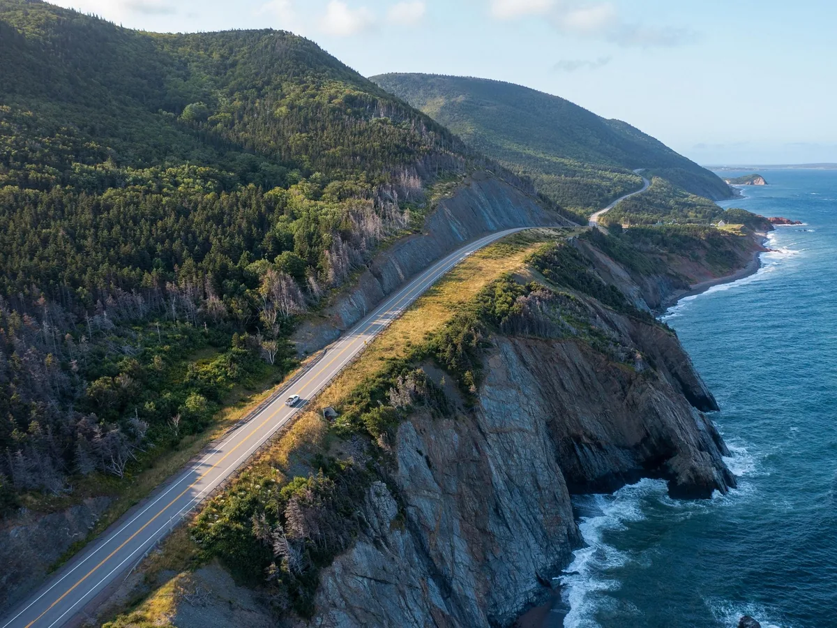
A thousand feet above the Gulf of Saint Lawrence, the road narrows to a single strip of grey between a sheer granite wall and the infinite blue of the North Atlantic.
About Cabot Trail
Long before the first surveying teams arrived in the early 1900s, this rugged terrain was the exclusive domain of the Mi'kmaq, who moved through the mountain passes according to the seasons. The modern road was the brainchild of local visionaries and the Canadian government, who sought to stimulate the economy during the Great Depression through ambitious infrastructure. Laborers used steam shovels and dynamite to carve the road out of the Appalachian range, often working in conditions that would be considered impossible today. By the time the final bridge was settled in 1932, the trail had effectively stitched together two distinct worlds: the Scottish Highlands of the west and the French Acadian shores of the east, creating a cultural loop that is as diverse as the geology it traverses.
Nearly three hundred kilometers of asphalt ribbon cling to the serrated edge of Cape Breton Island, carving a path between ancient highland plateaus and the churning white foam of the Atlantic. The Cabot Trail serves as a spectacular transition zone where the boreal forest of the north collides with the maritime warmth of the Gulf Stream. On a clear morning, the vista from the French Mountain summit offers a perspective of the coast that feels less like a road and more like a flight path. The air is a crisp, salty tonic, carrying the scent of balsam fir and the faint, briny aroma of lobster traps drying in the sun. It is a landscape of high-contrast beauty, where the deep emerald of the spruce trees meets the bruised purple of the distant sea.
Named for explorer John Cabot, who purportedly sighted these shores in 1497, the actual loop was a feat of 1930s engineering intended to pull the isolated fishing villages of the north into the modern era. Before the road was completed in 1932, the Gaelic-speaking communities of the western coast and the Acadian enclaves to the east were accessible largely by sea or treacherous mountain trails. The construction was a grueling exercise in blasting through solid granite and bridging salmon-rich rivers, often using little more than manual labor and sheer maritime will. The creation of the Cape Breton Highlands National Park in 1936 further solidified the trail's status, ensuring that the wild interior would remain a sanctuary for moose and eagles rather than falling to the sawmills.
The hum of tires on pavement is frequently replaced by the deep, resonant thrum of the wind as you crest the North Mountain plateau. You notice the way the light changes from the soft, misty greys of the Margaree Valley to the blinding, crystalline blue of the coastline near Pleasant Bay. The soundscape is a mixture of crashing surf and the sudden, rhythmic clatter of a fiddle being played in a roadside barn.
Walking the Skyline Trail, the ground feels springy with moss and crowberry, leading you to a wooden boardwalk that hangs suspended over a thousand-foot drop. You notice the white dots of gannets diving into the sea far below and the dark silhouettes of pilot whales breaking the surface in the distance. Most visitors focus on the driving, but the true spirit of the trail is found in the quiet Acadian harbors where the colorful fishing boats bob in perfect unison with the tide. The moment that stays with you is the descent into Ingonish at sunset, when the mountains turn a dark, velvety indigo and the first lights of the village begin to twinkle like fallen stars against the black water.
Entering the loop usually begins at Baddeck, a town nestled on the shores of the Bras d'Or Lake that serves as the southern gateway. From here, travelers choose to navigate the trail in either a clockwise or counter-clockwise direction, with the latter putting your vehicle on the outside edge of the cliffside drops for maximum exposure. The road is well-maintained but demanding, featuring hairpin turns and steep grades that require a patient foot on the brake. For those who prefer a slower pace, a growing number of cyclists tackle the elevations, though they must contend with the unpredictable North Atlantic weather that can bring fog or sun in a matter of minutes.
The Experience
The air at the summit of MacKenzie Mountain is noticeably colder and carries a prehistoric stillness that makes the engine's noise feel like an intrusion. You feel the constant pull of the geography, a physical sensation in your chest as the road dips and climbs through the ancient canyons. You notice the subtle shift in the forest, where the hardwoods of the valley give way to the stunted, wind-gnarled krummholz trees of the highlands. Most travelers overlook the small, unpaved side roads leading to hidden beaches like Black Brook, where the sand is dark and the water is surprisingly clear. You feel the spray of the Mary Ann Falls on your skin, a cooling mist that smells of wet stone and wild ferns. The moment that lingers is often found in a roadside bakery in Chéticamp, where the smell of fresh bread and the sound of spoken French remind you that this road is a lifeline for living communities, not just a scenic bypass.
Why It Matters
The Cabot Trail is more than a scenic drive; it is a cultural artery that preserves the linguistic and musical heritage of the Gaelic and Acadian peoples. It matters because it protects one of the last truly wild coastal wildernesses in North America while providing a portal into a way of life defined by the sea. Humanly, it stands as a monument to the resilience of the communities who carved a home out of the rock and the wind.
Why Visit
Visit the Cabot Trail because it offers the rare sensation of being at the very edge of the continent without the crowds of more accessible shores. You go for the dramatic cliffside curves, but you stay for the highland silence that can only be found when you turn off the ignition. It provides a raw, unpolished encounter with the North Atlantic that no other road in Canada can match.
✦ Photo Gallery
Best Season
🌤 Plan your journey for the first two weeks of October, when the highlands erupt in a riot of pumpkin-orange and crimson maples, and the crisp air provides perfect visibility for whale watching.
Quick Facts
Location
Canada
Type
attraction
Coordinates
46.4869°, -60.7461°
Learn More
Wikipedia article available
Insider Tips
- 1
Drive the loop counter-clockwise if you want to be on the ocean side of the road, offering the most direct and unobstructed views of the cliffs.
- 2
Pack a heavy sweater even in July, as the temperature on the highland plateaus can be fifteen degrees lower than in the coastal valleys.
- 3
Stop at the small craft shops in St. Ann's to see traditional looms in action; the local weavers still produce tartans found nowhere else in the world.
- 4
Hike the Skyline Trail at dawn to see the resident moose population before they retreat into the deep woods to escape the midday heat.
- 5
Fill your gas tank in Baddeck or Ingonish, as the northern stretches of the trail have very few services and cell reception is virtually non-existent.