The deepest river canyon in Europe was largely unknown until a speleologist made the first full descent by boat in 1905 — a three-day journey through a gorge local people believed impassable and associated with supernatural dangers.
About Gorges du Verdon
Édouard-Alfred Martel's 1905 descent of the Verdon opened the gorge to public knowledge and exploration. The Lac de Sainte-Croix reservoir at the western end was created in 1974; the surrounding plateau and lavender fields of Provence frame one of France's least industrialized natural landscapes.
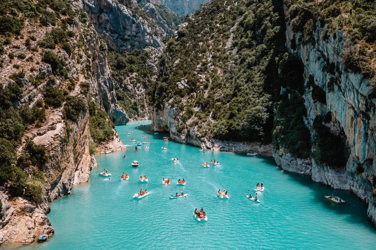
Overview The Gorges du Verdon in Provence is the deepest river canyon in Europe — the Verdon River cuts through limestone plateau to depths of up to 700 metres over a gorge length of approximately 25 kilometres between Castellane and Lac de Sainte-Croix. The turquoise color of the Verdon River, produced by calcium carbonate from the limestone it runs through, and the scale of the canyon walls give the gorge a visual quality more associated with the American Southwest than southern France.
The Story Behind It The Gorges du Verdon were largely unknown outside the immediate region until the speleologist Édouard-Alfred Martel made the first full descent of the gorge by boat in 1905 — a journey that took three days in a landscape he described as one of the most extraordinary he had encountered. Before Martel's expedition, local people believed the gorge to be impassable and associated it with supernatural dangers. The gorge's remoteness and difficulty of access preserved it from development through most of the twentieth century; the Lac de Sainte-Croix reservoir at its western end was created in 1974 by damming the Verdon.
What You'll Experience The gorge is accessible from both the north and south rims, connected by vertiginous roads with belvedere viewpoints at regular intervals. The Route des Crêtes (north rim) and the Corniche Sublime (south rim) together offer about 130 kilometres of driving with canyon views. The Sentier Martel — named for the first explorer — descends into the gorge floor for a two-day walk, requiring advance tunnel booking for the sections of path inside the cliff. Kayaking and paddleboarding on the Verdon from Lac de Sainte-Croix, where the turquoise water is accessible at lake level, is the most popular summer activity. The lavender fields of the Valensole plateau, visible from the gorge's eastern approaches, are in bloom in June and July.
Getting There The nearest city is Digne-les-Bains, accessible from Marseille by a spectacular narrow-gauge railway. The gorge itself requires a car — the rim roads are the primary access and no public transport serves the viewpoints. Moustiers-Sainte-Marie at the gorge's western end is the most useful base.
The Experience
Drive the Route des Crêtes and Corniche Sublime rim roads stopping at the canyon belvederes, walk the two-day Sentier Martel through the gorge floor, kayak or paddleboard on the turquoise Verdon from Lac de Sainte-Croix, and time a visit to catch the Valensole lavender in June or July.
Why It Matters
Europe's deepest river canyon and the most dramatic landscape feature of Provence — a 25-kilometre gorge with 700-metre walls and river water of an unusual turquoise that has no European equivalent.
Why Visit
The canyon from the rim belvederes is what photographs show; the Sentier Martel floor experience — walking inside the gorge with the walls rising vertically on both sides — is what makes the canyon a complete place rather than a viewpoint. The turquoise river at the lake is genuinely improbable.
✦ Photo Gallery
Best Season
🌤 May through September. June and July for lavender fields on the plateau. Summer weekends bring significant kayak and paddleboard crowds at the lake entrance; weekday visits are more manageable. The Sentier Martel requires dry-weather conditions.
Quick Facts
Location
France
Type
attraction
Insider Tips
- 1
The Sentier Martel tunnel sections require advance booking — contact the Castellane tourist office for permits.
- 2
Kayak rental at Lac de Sainte-Croix is available from multiple operators at the water's edge; paddling up the gorge entrance is the best way to appreciate the canyon scale from water level.
- 3
The Route des Crêtes (north rim) gives the higher and more dramatic canyon views; the Corniche Sublime (south rim) is less vertiginous.
- 4
A car is essential — no public transport serves the rim roads or the gorge viewpoints.