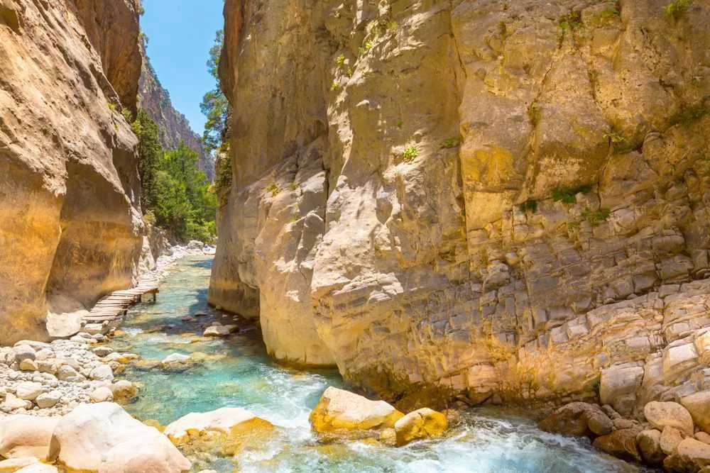
At the narrowest point of Samaria Gorge, the walls are 3.5 metres apart and 300 metres tall — and the village halfway through was inhabited until 1962, when the national park designation required its residents to leave.
About Samaria Gorge
Human use of the Samaria route predates recorded history — the gorge was the natural crossing of the White Mountains between the northern coast of Crete and the Libyan Sea. The village at its midpoint was continuously inhabited through the Byzantine, Venetian, and Ottoman periods. During the German occupation of Crete from 1941 to 1944, the route acquired strategic significance as an escape corridor; Allied soldiers and Cretan resistance fighters used it to reach boats on the southern coast. The gorge was designated a national park in 1962, partly to protect the kri-kri, a Cretan wild goat subspecies with curved horns that exists nowhere else on earth. The resident population of Samaria village was relocated at the same time. The park is closed from November to April, when the dry river bed fills with flash floods capable of moving boulders.
Overview At the Sideroportes — the Iron Gates — the walls of Samaria Gorge close to 3.5 metres apart at a height of 300 metres. The slot is narrow enough that a person with arms extended can touch both rock faces. A stream runs through the base in spring; in summer it is dry gravel, and the sound of footsteps in that enclosed vertical space is absorbed immediately. The gorge cuts through the White Mountains of western Crete for 16 kilometres, dropping 1,250 metres from the Omalos plateau to the Libyan Sea, and has been walkable as a through route for as long as anyone has needed to cross the mountains.
The Story Behind It The village of Samaria, roughly at the gorge's midpoint, was inhabited until 1962, when the designation of the gorge as a national park required its residents to relocate. The stone houses, the church of Osios Ioannis, and the vegetable plots visible from the path are now empty, slowly being reclaimed by vegetation. The park was established partly to protect the kri-kri — the Cretan wild goat, an endemic subspecies found only in the White Mountains and on three small offshore islets. During the German occupation of Crete from 1941 to 1944, the gorge served as an escape route: resistance fighters and Allied soldiers evading capture used the route to reach boats waiting on the Libyan coast below.
What You'll Experience The walk is one-way downhill, from the Xyloskalo entry at the top of the plateau to the exit at Agia Roumeli on the coast — there is no road at the bottom, which is why the return to Chania requires a boat to Sfakia and then a bus. Total walking time for an averagely fit adult in good conditions is four to six hours. The upper section traverses pine forest with mountain views; the gorge narrows progressively through the middle section before the Iron Gates in the lower third. The kri-kri are most visible in the early morning in the upper section before the main flow of walkers disturbs the slopes.
Getting There Buses from Chania depart for the Xyloskalo entry at the top of the gorge from approximately 6am during the open season (May to October). Return to Chania from Agia Roumeli requires a boat to Sfakia followed by a bus — allow the full day.
The Experience
The upper section of the walk, through pine forest descending from the plateau, is spacious and relatively easy. The gorge begins narrowing noticeably after the first few kilometres, the walls rising and the light changing quality as the sky above becomes a narrower strip. The Iron Gates, reached in the lower third of the walk, require no climbing — you walk through a slot in the rock where the path is the river bed, the walls close on both sides, and the sound of the place is entirely different from the open sections above. The kri-kri are genuinely there, most reliably spotted in the early morning along the upper rocky slopes. Moving quietly before the first wave of walkers is the practical approach. The exit at Agia Roumeli — a small beach settlement on the Libyan Sea — is one of the more satisfying arrivals: you have crossed the mountains on foot.
Why It Matters
Samaria is a functioning natural system — an active river gorge, a genuine wilderness by European standards, with endemic wildlife and a topography that has not been substantially modified. The kri-kri survive here because the terrain is too difficult for the feral goats that have displaced them elsewhere on Crete. The gorge is not a managed experience; it is a place with its own conditions, and it makes those conditions clear.
Why Visit
Samaria is a physical challenge with a genuine payoff: the Iron Gates, the empty village, the quality of light in a 300-metre slot canyon, and the arrival at the Libyan Sea after six hours on foot. The walk is not technically difficult, but the distance and the heat require preparation. The experience of walking out of a gorge onto a beach accessible only by boat is specific to this place.
✦ Photo Gallery
Best Season
🌤 May to June and September to October. The gorge opens in May after winter flood clearance and closes in October. July and August are very hot in the lower sections and have the most walkers; the early morning start (first bus from Chania) partially mitigates both.
Quick Facts
Location
Greece
Type
attraction
Coordinates
35.2711°, 23.9614°
Learn More
Wikipedia article available
Insider Tips
- 1
Wear shoes with ankle support, not sandals — the gorge floor is loose rock and dry river gravel for much of the lower section.
- 2
Carry more water than you think you need; water refill points exist but are not reliably frequent.
- 3
Taking the first bus from Chania (around 6am) puts you on the trail before the main groups and gives the best chance of seeing kri-kri in the upper sections.
- 4
Book the return boat from Agia Roumeli before entering the gorge — departures are limited and fill up, particularly in the afternoon.