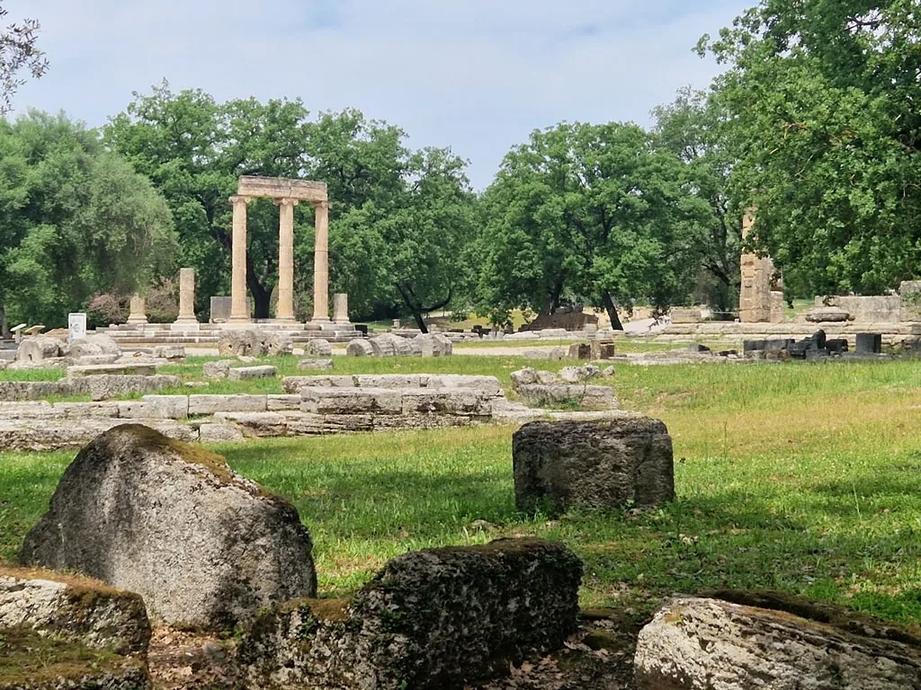
Milos obsidian was the sharpest cutting material available in the prehistoric Mediterranean, and trade networks carrying it have been traced back to 10,000 BCE — the same volcanic geology that produced that resource also created Sarakiniko's white lunar landscape.
About Sarakiniko
Milos owes its prehistoric significance to the same volcanic system that shaped Sarakiniko. Obsidian outcrops on the island in quality suitable for tool-making, and Milos obsidian has been identified at archaeological sites from the Greek mainland to Egypt, demonstrating Aegean trade networks extending back to the tenth millennium BCE. The island's commercial importance faded as metal tools replaced obsidian, but its geological identity persisted. Sarakiniko specifically has no recorded history before the modern period. The name references Saracen pirates who reportedly used the sheltered cove; the tuff formation was simply the local coastline. The twentieth century's expansion of Aegean tourism, combined with aerial photography that made the formation's unusual shape widely visible, converted an obscure northern shore into a destination. The volcanic tuff formation itself is the product of submarine eruptions from the Hellenic Volcanic Arc and millions of years of subsequent sea erosion.
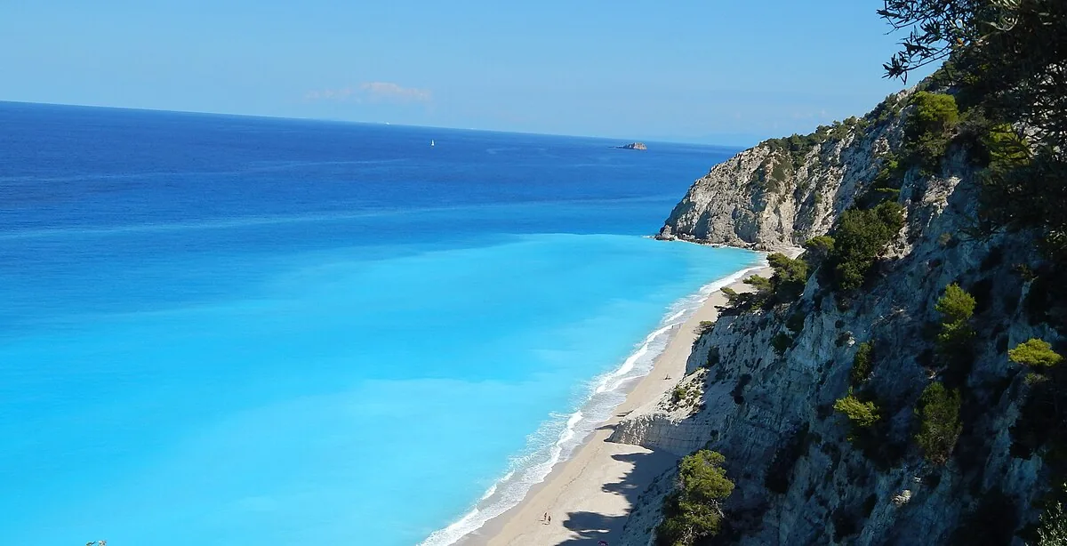
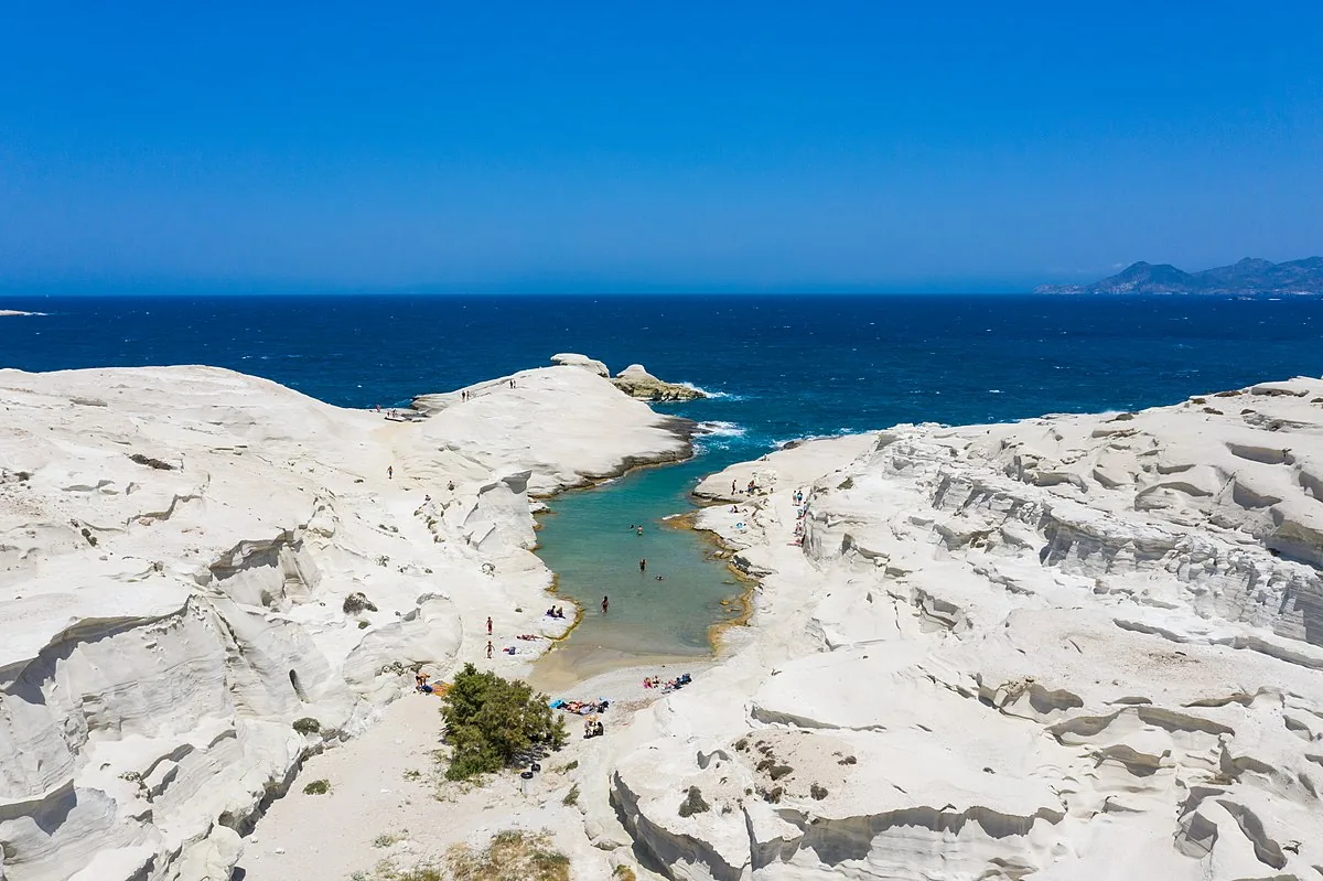
Overview Sarakiniko does not look like Greece. The northern shore of Milos presents a landscape of white volcanic tuff — smooth, rounded, eroded into domes and channels and sea-level pools by millions of years of wave action — that reads more like a desert or a moonscape than an Aegean island coast. The rock is pumice and compacted ash from submarine eruptions on the Hellenic Volcanic Arc, the same geological system that produced Santorini's caldera. Here the material was exposed on land rather than sea-floor, and the Mediterranean's specific combination of wave and salt has carved it into forms with no visual precedent in standard Greek island geography.
“The rock is pumice and compacted ash from submarine eruptions on the Hellenic Volcanic Arc, the same geological system that produced Santorini's caldera.”
Sarakiniko, Greece
The Story Behind It Milos sits above one of the Mediterranean's most active volcanic zones, and its geological history made it the most important resource island in the prehistoric Aegean. Obsidian — the volcanic glass that was the sharpest cutting material available to Neolithic and Bronze Age cultures — outcropped on Milos in quantity and quality. Milos obsidian has been found at Neolithic sites from mainland Greece to Egypt, demonstrating trade networks operating as early as 10,000 BCE. The island's economic significance shifted through the classical and medieval periods, but its volcanic geography remained distinctive. Sarakiniko itself had no strategic significance — it was a fishing anchorage, named for Saracen pirates who used the protected cove — and the tuff formation was simply part of the northern coast until the twentieth century made it a destination.
What You'll Experience The formation is accessible on foot from the road above, a five-minute descent to the rock surface. The main white formation extends along the coast for roughly 300 metres, with multiple levels: flat sections for sitting, narrow channels carved by wave action, and coves where the tuff meets the sea. The water clarity in the coves is exceptional — the volcanic rock produces no suspended sediment. Swimming is possible from the rock edges where they slope into the sea; the channels between formations create protected pools at low swell.
Getting There Milos has a small airport with Athens connections and a ferry port at Adamas. Sarakiniko is 5 kilometres north of Adamas. Local buses serve the route; scooter or car hire covers Milos's other geological sites efficiently.
“Getting There Milos has a small airport with Athens connections and a ferry port at Adamas.”
The Experience
The colour of the rock changes through the day. In flat midday light the tuff reads white-grey, and the photographs taken then are the ones most commonly reproduced. In the late afternoon, when the sun drops toward the west, the surface picks up warm tones and the channels between the formations cast actual shadows — a different place, with the forms suddenly legible as three-dimensional. Swimming from the rock edges is one of the specific pleasures of Sarakiniko. The water enters the coves between the tuff formations with unusual clarity — the volcanic rock produces no fine sediment — and the depth drops quickly from the shore. Arriving in the early morning before the day visitors from Adamas gives the formation a quality that midday, with its crowds and flat light, does not provide.
Why It Matters
Sarakiniko is the surface expression of an ongoing geological process. The Hellenic Volcanic Arc is active; the tuff formation is still being eroded; the island below the Aegean has erupted within historical memory. What looks like a finished landscape is a slow-motion event. That context — the obsidian trade routes of 10,000 BCE, the same system that destroyed Minoan Crete, the white rock being carved by the same sea — gives a beach visit an unusual depth.
Why Visit
The photographs are accurate but incomplete. The scale, the three-dimensionality of the channels and domes, the quality of the water in the coves, and the shift in the formation's character from midday to late afternoon are things the aerial image does not convey. Milos also has other volcanic geological sites — the coloured earth cliffs at Paleochori, the sea caves at Kleftiko — that make the island worth more than a single beach visit.
Insider Tips
- 1
The late afternoon light (3pm to sunset) transforms the formation in a way that the flat midday light does not — worth the extra hours if you arrive at midday.
- 2
Water shoes are useful for entering the sea from the tuff edges, which are sharp in places.
- 3
Kleftiko, the sea cave formation on the island's southwest coast, is inaccessible by road and requires a boat tour from Adamas — the combination with Sarakiniko makes a full geological day.
- 4
The road above Sarakiniko has a small car park; arriving before 9am in summer is the practical way to avoid the worst of the midday crowd.